Brew Hut
Winter access: 7 hrs
Hut fee: $15 per person per night
About Brew Hut
About Brew Hut
Notice: Wood at the hut is green and hard to light. We would recommend bringing dry kindling.
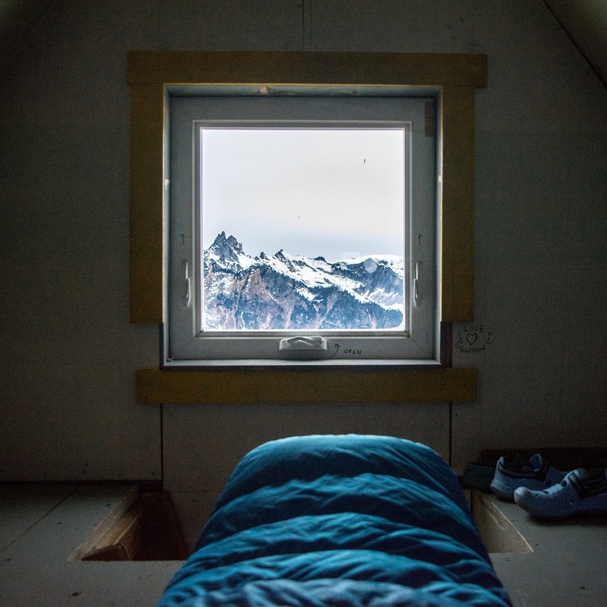
This hut was built in 2005 and sits at 1686 m on an exposed alpine ridge just south of Mt. Brew. It sleeps about 12 people comfortably, but it has fit as many as 20. The hut is open to non-motorized, non-commercial users.
The Brew area receives huge amounts of snow in winter and is a popular destination for backcountry skiing. In summer, hikers visit the heather meadows around Brew Lake, swim in the tarns, and walk up nearby Mt. Brew.
The hut has a wood stove (winter use only), a solar-powered light, and an outhouse. Firewood should be used sparingly, because it is carried in by volunteers. There are small tarns west of the hut for drinking water (no swimming!), although in winter it is sometimes necessary to melt snow. For more information, see the VOC Wiki.
How to get there
Turn onto Chance Creek FSR from Hwy 99 (1.8 km south of the Garibaldi Rubble Creek turnoff). The road is rough but passable for 2WD vehicles until near km 4 or km 5. In winter, park in the ploughed parking lot at km 1.6, shared with snowmobilers and Powder Mtn Catskiing. Continue up the road and keep right at major junctions. In summer, park at the new bridge over Roe Creek (km 5.9). For the next 2.5 km, the road is heavily deactivated and is slow travel on skis (but fine in summer). Stay right at major junctions until the trail leaves the road in a cutblock (50.00728, -123.18716; easy to miss). Walk through the forest to Brew Lake, then follow gentle slopes northwest then north to a col. The hut is just east of the col.
In winter, this route is 13.2 km and 1300 m elevation gain. In summer, it is 9.0 km and 990 m elevation. The last section of trail is in open subalpine terrain, is unmarked, and is covered by snow well into the summer. Whiteout conditions are common in every season, and you should have a GPS or be proficient navigating with a map and compass to reach the hut. In winter and spring, there are a few short sections of avalanche terrain.
2022 Brew GPS track
Conditions reports
New reportTrail for the most part well marked Kieva D
The hut was nice and tidy when we made it up, with the firework shed pretty much full. We struggled a bit at around 6 km to find the trail and got lost for a bit. Consistent snow coverage begins at around 1400m just before the tree line breaks (last couple kms). We didn’t see any wildlife on the track. Thanks for all you do VOC!
June 23, 2025
Definitely need 4wd with higher clearance since fsr contitions are getting worse every year.
Mosquito land for the first 7kms
Last 3kms up to brew was mostly snow covered with patches of dirt and streams of water. With no mosquitoes, very few at top.
Hut in good clean condition. There is a coleman stove at the top, not sure if it works.
Some dude slept with his dog up on the second floor
Lake snow covered.
June 22, 2025
Road in good shape, newly graded as far as the mine on the day I drove up. Still lots of snow from well below the lake.
May 27, 2025
It took our group just shy of 6 hours to get to the hut. The trail is not in the greatest condition. With the warm weather, expect heavy wet snow during the day and a thick icy crust on the way down the next day. The view up there is incredible and was worth the climb. The hut is very cozy and has a few extra sleeping mats and sleeping bags. The wood stove is in GREAT NEED OF ATTENTION/MAINTENANCE. The smoke won't go up the chimney until it's warm enough to bring the smoke up which may take about 40 mins. During that time smoke accumulates in the hut, which is not great. We did open the stove key to get fresh air in from the bottom and tried to find the driest wood, but everything in the hut was wet wood and took a long time to start burning.
Beside that everything else was nice and overall good experience!
Cheers,
Phil
March 2, 2025
Took us 8 hrs to go up with snowshoes. Parked about 1.2km before the trailhead. We were the first one to break the trail with snowshoes after the snow storm earlier. Even with snowshoes, we were still postholing. Many back country skiers, but it didn't compact the snow hard enough for hikers with snowshoes. Really long but worth it. If you are going with snowshoes, wear large snowshoes with an extension tail. A cozy & cute hut rewards you at the end of the hike. Stunning views along the way and at the hut.
March 1, 2025
Went up expecting the crowds this weekend, but we ended up with the hut to ourselves!! Crazy! Shout out to Mat who packed up a new large pot for melting snow! We left the old one there for snow scooping, but Scott packed out a bunch of other trash. We tried really hard to keep the fire going, but sadly failed both nights. We split a lot of kindling and spread it out to dry out a bit....but I still would not rely on it. Bring extra fuel for melting snow.
Snow was ace, and I'm very glad we didn't have to fight for freshies!!
7.5 hrs in, lots of breaks!
My Theory on the wood stove is that there is not enough airflow up. Might need a coat hanger or something to clean it out of all the carbon buildup. Low airflow + wet wood = no fire and very smoky cabin.
Feb. 17, 2025
Parked at snowmobile parking lot, had to carry skis a few km up the track due to so many rocks and dirty snow. Forest section was challenging and icy in parts. Nice skinning once at sub-alpine. Took 6.5 hrs to get up with plenty of breaks. Brought up ~10lbs of wood and split some more once we were up there in anticipation of the long weekend crowds. Biggest pot doesn’t hold water. Hut in good condition, 3-4 spare mats and sleeping bags, and they have a cribbage board so don’t bring your own!
Skiing off the ridge was beautiful, some wind affected snow but otherwise perfect. Lots of transitions necessary in the forest and creeks area (please don’t boot pack the skin trail!!!).
Feb. 13, 2025
Our group of four hiked the trail in boots and microspikes and decided to leave the snowshoes behind. For the most part, this worked out quite well with some post-holing in the upper FSR and alpine and we made it to the hut in about 5.5 hours at a moderate pace. The warmth on Sunday (Jan 27th) started to soften the hard crust that formed over the past few weeks but all in all, things held together pretty well.
There is now enough kindling up there to start a fire but I would still recomend bringing up a small amount and some paper to start a fire.
The hut is in good shape but some of the pots have holes in them so I would defintely recomend brining your own pots to cook in and your own stoves to cook on.
Jan. 27, 2025
Both big pots for melting snow have cracks in them
Jan. 24, 2025
Parked about 3k up the road. Lots of rocks in the snow for a while as you head to turn off the cat road. There is a number of little creek crossings before you get to the actual trail. The trail was pure ice in the trees. My ski crampons were the best thing that anyone brought for the trip.
Our group of 6 took 6.5 hours to get in, average pace with breaks, fighting the ice. I think we could have shaved an hour off if it wasn’t for the sliding.
We trekked in a couple pieces of wood each, and a bunch of dry kindling. We didn’t actually use it all so we left it up there for the next groups. This was awesome to get the fire going. We saw lots of wood in the shelter next to the cabin and some buried way down in the snow. If you’re going in bring dry kindling and paper at least. The wood is wet and indeed hard to light.
The cabin was warm and cozy, we had a great time. 8 of us that night. Skiing was wind affected and crusty but still totally worth it!
Jan. 24, 2025
Bring dry kindle and fire starter with you!! We tried really hard to start a fire but were unable to because the kindle and wood were wet. It was a cold night but we managed to stay warm.
The first 2km of the FSR were snow free; we parked the Highlander at the 3km mark, which saved us a lot of time. Total hike was 10.5km / 6 hours up. No snowshoes needed, the snow was well packed and micro spikes were handy to navigate the icy sections.
The hut is in good condition and was a great shelter from the cold. We were 9 people and all fit comfortably; anything more than 12-14 would’ve been too crowded.
Jan. 18, 2025
It took 10 hours to ski/snowshoe to the hut. Fast parties will be faster.
We parked near the start of the Roe Creek FSR and could start skinning right away. Lots of sledders. Once on the branch road, we frequently had to take off our skis for creek crossings.
The trail through the forest was mostly easy skinning, except for a few places, where it was very icy. There were a couple of places where the skin track unnecessarily went through a steep boulder field that could avalanche. It would be smarter (and not very difficult) to skin below these avvy paths. Be aware of your route choices!
Above the forest, the skin track was well-formed and pleasant. If skinning in a whiteout, make sure to follow the GPS track so you don't wander into avalanche terrain.
At the hut you need to melt snow for water. The hut seemed in good repair.
Going down, it was much faster to bootpack through the forest part (because it was icy), except for superb skiers.
Jan. 12, 2025
Even though we heard about the firewood delivery, we decided to haul up 2 budles of firewood in a sled to be safe. We parked at about 500m from the bridge as the crosstrek couldnt make it any further with 2 chains in the (cattracked) deep snow. The washout before the bridge is backfilled with snow, we heard by the snowmobilers to not attempt to cross it with your car. Cross ditches were relentless and groomed before the turn onto the R200 spur. Hauling the wood up was the hardest part of the trip. The deep snow made it drag into the skin track rendering it harder to pull and kept filling with snow. At one of the cross ditches tipped over into one of these rendering our wood soaking, which made the sled even heavier. arrived at the hut at 415 just over 6hr in a total whiteout. We couldn’t find the recently delivered firewood due to snow coverage so our wood helped. We woke to a foot of snow and whiteout. Had to skin the way back down to the spur r200 (too much snow for any momentum).
Dec. 28, 2024
This weekends tropical storm brought down a lot of rain. Got to about 575m on Chance Creek with an Impreza- cat tracks from there to the bridge are no longer skiiable. Going up on the 20th was noticeably more filled in than down on the 21st around the waterbars on Roe Creek R200. Firewood situation is dire- we brought up a 6in log- please continue to bring more on foot as there are mayybe 20 pieces at the hut.
Dec. 21, 2024
Unfortunately I couldn’t make it to the Brew hut due to poor weather conditions and I turn it back.
I tried approach from Whistler campground and I made mistake,as that side is not really passable.
Next time I will go with Roe creek
Dec. 19, 2024
Had a lovely overnight at Brew on Monday. Thanks VOC- can't wait to come back! We appreciated the birthday hats/sash left behind. Some notes:
Could drive to summer parking with chained Forester but likely no longer possible with recent storm.
Many skis on skis off creek crossings - at casual pace it was 7 hr to hut, 3.5 hr down
Woodpile outside hut getting buried - moved a few in but next party should move the rest in before they get covered/stuck. Only about 20 large rounds inside woodshed.
Winter toilet door had been left open - ensure ice cleared from doorjam and leave latched closed
Guitar D string tuning peg could likely be fixed with some super glue/wood glue and small screws- I have pic
Need a new logbook, only a few pages left, and new sign for door (illegible)
Did a general tidy, wiped out 2nd snow melting pot that had been used for ash but could use a deeper clean.
No fresh mouse activity noted but having traps available could be nice
Dec. 18, 2024
Brew Hut is freshly supplied with firewood. You'll have to split it yourself. Please use it sparingly - getting this load up there cost nearly $3000.
There is also firewood under a tarp at the summer parking - if your pack feels too light, please carry some of it up. It will help us avoid the need to use helicopters in the future.
Roe Creek FSR is driveable to the summer parking lot without chains, though the last ~1km starts to get snowy and has some ice. The water bars on the upper road are still open, and coverage on the trail is thin but apparently mostly skiable.
Dec. 9, 2024
We came up to ski for a couple days. From 1000-1300 meter was quite unpleasant on the approach. We put skis in at 1350-1400m. If I had known about the mouse I would have brought a trap. Hang your food well. It is feisty! I also must note that there is essentially no firewood. If you plan on having a fire you will need to carry wood. I split the remainder of the wood from the shed but it is not very much at all. People have been sawing the local trees for wood which is definitely poor style! Otherwise the hut is in reasonable shape. We gave it a good sweep and clean when we got here since it was needed. The guitar needs a D string although it’s on its last legs.. Update: it’s a family of mice. At least 3 or 4.
Nov. 16, 2024
A group of 6 of us tried making it to the hut but the trail was very snowy and visibility was low, so it was hard to follow. Conditions were cold and miserable and snow was deep. We didn't make it to the hut and decided to turn around.
Nov. 16, 2024
Got a solid dump of snow while I was there, the hike down had very different conditions from the hike up – I definitely wished I'd had longer snowshoes/tails on the descent. For a bunch of the hike I was getting mixed precip, so it might be icy in the next few days if the temperature drops. GPS was also super handy given the whiteout.
I second the previous post, strongly recommend bringing paper for the fire. I dried out some wood on the stove and left it on the shelf above the ground with a bit of extra kindling in the stove, so that's probably the best place to start. Also the mouse is getting a bit bold around people, a trap might be necessary.
Nov. 14, 2024
Parked the evo a mile from the summer parking lot. Walking on the road is fine, lots of little stream crossings. Cairn to trail is very easy to miss, 2 of us walked a mile past it before realizing. Trail itself is mostly following a stream up the mountain, lots of mushrooms to see! We put snowshoes on about halfway to Brew Lake. Lots of layers, snowshoes and gps are a must for navigating the snow. We followed some tracks for a while but when it started snowing they quickly got covered. We hiked the last few miles in the dark. Hut’s doing good, guitar needs a new string, had to go outside to close the window we opened. Axe needs to be sharpened, and bringing some paper for firestarter is a good idea. Got about 130 cm of snow overnight, hike down was white out but beautiful.
Nov. 12, 2024
Glad we brought snowshoes to avoid pot-holing. The snow was wet and heavy on saturday(9th) then rain and froze overnight now it’s very crusty. The hut was in decent condition. There was a small mouse we could’ve caught him but he wasn’t harming anyone so we just hung everything food related to the roof. There was very little firewood we brought some in from the small shed to dry and replace what we burnt.
Recommend bring up dry wood, and kindling to get it going.
Nov. 10, 2024
Date: November 2-3, 2024
Route: Roe Creek
Distance: Total 9.38km each way (~5 km on FSR & ~5 km from old trailhead to hut)
Total Time: 5 hours up to the hut, 3:45 down
Conditions: ~2-3 feet of fresh snow at the hut
Had a great night up at brew hut. Saturday was cloudy with a little snowfall. Sunday morning on our way out was sunny and beautiful. Hut has 2 large pots for snow collection, a couple extra summer sleeping bags and some yoga style sleeping mats.
If you're heading up plan for snow and cold. Gaiters and proper boots were enough for us.
We did lose a can of bear spray (fell out of a side pocket without being noticed). If anyone comes across a Fronterisman can please reach out.
Nov. 2, 2024
We drove a SUV MODO car up till the Summer parking lot. That went well! There were some really big gaps on the FSR that was sometimes difficult to get over with the car.
The trail via roe creek was good! There was so mud here and there, that makes it slippery. Waterproof shoes are a must, maybe some gaiters and pols are good for the balance. If you love Mushrooms there are all kind of mushrooms 🍄 on the way really cool. There is no snow around the summit yet. The Views where amazing! On the way up, follow the rock piles, these help keep you on track. There is one on the FSR to the start of the real trail ahead. In the hut there are 6 spare mats and 3 warm sleeping bags. There is a stove and people tried to use it but they couldn’t figure how it works. So bring extra little stoves for Iron Chef. There are still 2 cooking pots. We had a great time! We all loved it. We are back soon Brew! 😊
Oct. 15, 2024
The trail via roe creek is very wet, so waterproof shoes are a must. There is a lot of snow close to the summit. On the way up, follow the rock piles, these help keep you on track.
The hut has around 6 spare mats and 3 warm sleeping bags. Packing a jet boil and a hot water bottle saved us. I wish I would have packed slippers for the hut. The hut has 2 cooking pots.
Oct. 5, 2024
The road to rogue creek was a bit tricky as there were some deeper holes. The trail was in good condition and easy to find. We didn't notice anything broken in the hut except for a role of toilet paper that was half eaten by a mouse (that we also saw at night).
Oct. 2, 2024
Started the hike up at 6pm on Sept 27th, got to the hut by 11:30pm. Fit 13 VOC'ers inside the hut (3 on the bench downstairs, 1 on the table, the rest upstairs). At night it was 4'C and the temperature in the hut was completely fine (no firewood used). The firewood shelter has some wood left for winter but should get restocked (a few logs inside Brew hut as well). The window beside the door (to your right as you enter) is broken but can be opened and closed by pushing it closed from the outside, no issues. Trail is in good shape. Snow fell and accumulated the morning of Sept 29th. Overall no issues, only great views!
Sept. 30, 2024
There are 2 windows with broken mechanism. You can open but not close them. They are the ones on the wall where there’s the counter. It’s still possible to close them if someone pushes the window from the outside of the hut.
The trail is becoming overgrown, especially at the first part, in the cutblock. There’s also some sections in the woods that is starting to be overgrown.
Otherwise the hut is beautiful. Thank you for the hard work!!
Aug. 20, 2024
Took about 4.5 hours to the hut and 2.45 hrs down. Road was fine to get up to. No issues in the hut!
July 27, 2024
The windows on the west side of the hut do not close with the crank. We tried to push them closed from the outside and were able to lock one but not the other. One of the hinges is broken on the woodshed door as well.
July 20, 2024
The road was in perfect condition and there is no snow till we parked. We had to park in the first washout as it is impossible to cross so that adds 3.5 additional km to the hike. It took us 5.50 hours to get there from the parking lot
The hut was in perfect condition, low in wood tho
The trail was covered in snow after the first 2K and snowshoes are highly recommended. We got hit by a snowstorm on Saturday (May 18th) so please be prepared for all type of weather and we had -5 on Saturday night (again be prepared)
Some mice inside the hut, please be careful with the food and don’t leave garbage behind.
Thank you VOC, you are amazing 💜
May 20, 2024
One member of the group had bad knee, we turned around 7 km up the trail because the pace on the small trail went down to 1 km/h. Snow was patchy on the upper part of the clear cut area. Very slushy and heavy snow. Heard and saw avalanche on the opposite mountain.
May 3, 2024
Road is consistently snow-free up to R200. From there it's patchy for a few hundred metres before it becomes a struggle to walk. Others might think it's worth the sufferfest to ski, but we were quite happy to opt for slowshoes and enjoy the views.
Please email me at [email protected] if you come across my (quite new) Nalgene which I stowed quite carelessly on my pack on the way down. Who knows, there may be a beer in it for your trouble ;)
April 17, 2024
If puffy is yours contact me [email protected] to arrange pick up. Skiable from the R200 branch (minus 1 or 2 stream crossings) and could drive to summer lot and skin from there with some avoiding gravel patches.
March 30, 2024
We had to park at 4.2 km of Roe Creek fsr due to snow. Snow was patchy up to the first switch back where we headed up R200. It is still possible to ski down to Roe Creek Road if you take your skis off for the cross ditches. All of these are melted and flowing. Snow is firm and spring like. We had about 10 cm of fresh snow on top of corn snow and ice. The cabin is in great condition, there is still fire wood left.
March 27, 2024
We went up last Sunday night using snowshoes. We parked our car at the junction where the gate is.
From there to the next junction branch R200 very little snow coverage. There is snow to start skiing at this point, the snow was hard until the hut.
The hut was very dirty downstairs. We cleaned and repaired the piece of metal under the chimney. There is firewood.
We had one of the best sunset ever!
Next morning it was white out conditions and snowing.
March 24, 2024
We took Brew mountain via Roa Creek Trail unfortunately past R200 snow patch was dense and we didn’t have snowshoes so had to turn back! We hiked 13Km with total 45pounds weight on our back and didn’t even make it to our destination! Wish we knew best trail to access the Hut.
March 17, 2024
After waiting for an unexpected bridge repair. We made it to the start of the trail around 11 AM. We found that there was no snow after the switchback on the fire road around kilometer seven we looked at the mountains around and saw that there wasn’t much snow either. decided to turn around
Feb. 22, 2024
Like others I ended up transitioning to my skis basically at the tree line, 1,350m or so. Snow was extremely variable but I had incredible views on Monday. Full whiteout for the ski out on Tuesday. I was able to ski a little lower into the forest, maybe 1,250m. Chopped a bunch of wood, gave the hut a good sweep and really enjoyed my stay. I’d say firewood shed is 1/3 full.
Feb. 19, 2024
Hike up to about 1350m elevation, don't bother even trying to ski, you will need to remove skis at every water bar on the road. Shouldn't need cramp-ons. Snow cover on the road got worse from after a day with the sun. We parked about 1.5km from the bridge/washout, road looked a little slick for 2wd.
Hut is clean and in great shape! There is a Carbon Monoxide alarm, however it was mounted up on the shelf above head height... it won't do much good there for anybody on the bottom floor, VOC should mount this near to the floor, thanks. Also, couldn't find a 2024 guest book!
Skiing was not great, thick icy crust on top of heavy snow, with many wind affected areas on top of it all, if you're only going for the views you might be better off in snowshoes. Survival skinning at best up to brew peak and keg peak. Good times!
Feb. 17, 2024